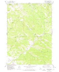
1977 Map of Stouts Mtn
USGS Topo · Published 1978About this map
Targhee National Forest defines the character of this high-elevation landscape, where a complex network of canyons and peaks straddles the boundary between Teton and Bonneville counties. The map documents a topography carved by water and ice, featuring prominent landmarks like Stouts Mountain, Liars Peak, and Chicken Peak. Significant for local history is the presence of West Pine Creek Girls Camp, a specific social use of the land situated near the confluence of West Pine Creek and Pine Creek. A system of Pack Trails and Jeep Trails provides the primary access through this wilderness area, connecting remote water sources such as Roy Farnes Spring, McCullock Spring, and Dry Canyon Spring. The nomenclature of the terrain reflects a mix of pioneer names and descriptive geography, from the suggestive No Cut Timber Canyon and Mike Spencer Canyon to the prominent Big Hole Mts in the northeast.
Find a feature on this map
40 named features on this map. Tap any name to fly to it.
Don’t see what you’re looking for? This feature index may not catch every label — zoom into the map to look around manually.
Map Details
Editions of this 1977 Stouts Mtn Map
2 editions found
Other maps of this area

1932 · Irwin
USGS Topo · 1:96,000

1935 · Irwin
USGS Topo · 1:125,000

1943 · Driggs
USGS Topo · 1:62,500

1943 · Garns Mtn
USGS Topo · 1:62,500

1946 · Driggs
USGS Topo · 1:62,500

1946 · Garns Mtn
USGS Topo · 1:62,500

1955 · Driggs
USGS Topo · 1:250,000

1958 · Driggs
USGS Topo · 1:250,000

1962 · Driggs
USGS Topo · 1:250,000

1966 · Conant Valley
USGS Topo · 1:24,000