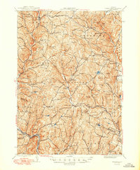
1944 Map of Strafford
USGS Topo · Published 1949About this map
Copper mining and rural hill-town life define this mid-century portrait of Orange and Windsor Counties. The industrial legacy of the region is anchored by the Elizabeth Mine and the Ely Mine (Inactive), while the agricultural and religious heritage of the area is represented by the Joseph Smith Monument near Sharon. The landscape is a network of named heights like Hawkins Mtn and Patterson Mtn, interspersed with small settlements such as Post Mills, South Strafford, and Tunbridge. Waterways including the White River and Ompompanoosuc River carve through the terrain, supporting clusters of schools like Old City Falls Sch and Turnpike Sch. This survey reveals a community connected by early state routes like VT 113 and VT 110, documenting many family-named hills and remote cemeteries that serve as vital touchstones for local genealogical research.
Find a feature on this map
121 named features on this map. Tap any name to fly to it.
Don’t see what you’re looking for? This feature index may not catch every label — zoom into the map to look around manually.
Map Details
Editions of this 1944 Strafford Map
5 editions found

Other maps of this area

1896 · Strafford
USGS Topo · 1:62,500

1906 · Hanover
USGS Topo · 1:62,500

1908 · Hanover
USGS Topo · 1:62,500

1911 · Woodstock
USGS Topo · 1:62,500

1913 · Woodstock
USGS Topo · 1:62,500

1919 · Royalton
USGS Topo · 1:62,500

1922 · Barre
USGS Topo · 1:48,000

1924 · Barre
USGS Topo · 1:62,500

1924 · Randolph
USGS Topo · 1:48,000

1926 · Randolph
USGS Topo · 1:62,500