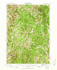
1944 Map of Strafford
USGS Topo · Published 1966About this map
Strafford and the surrounding hills of Orange Co and Windsor Co are defined here by a landscape of small upland farms and an industrial history of copper extraction. The mid-century topography reveals the deep roots of local copper production at the Elizabeth Mine and the Ely Mine (Abandoned), which once served as vital economic centers for the region. The map captures the dense network of one-room schoolhouses that still anchored rural life, including Dairy Hill Sch and School No 1.
Find a feature on this map
116 named features on this map. Tap any name to fly to it.
Don’t see what you’re looking for? This feature index may not catch every label — zoom into the map to look around manually.
Map Details
Editions of this 1944 Strafford Map
5 editions found

Other maps of this area

1896 · Strafford
USGS Topo · 1:62,500

1906 · Hanover
USGS Topo · 1:62,500

1908 · Hanover
USGS Topo · 1:62,500

1911 · Woodstock
USGS Topo · 1:62,500

1913 · Woodstock
USGS Topo · 1:62,500

1919 · Royalton
USGS Topo · 1:62,500

1922 · Barre
USGS Topo · 1:48,000

1924 · Barre
USGS Topo · 1:62,500

1924 · Randolph
USGS Topo · 1:48,000

1926 · Randolph
USGS Topo · 1:62,500