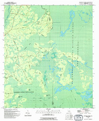
1994 Map of Strange Island
USGS Topo · Published 1994About this map
Okefenokee National Wildlife Refuge and Wilderness dominates this corner of Georgia, where the wetland landscape of Clinch and Ware counties is defined by a complex network of islands and prairies. This 1994 survey captures the intricate interior of the swamp, highlighting topographic rises such as Strange Island, Middle Strange Island, and the family-named Harpers Hammock. These dry points were essential for navigation and temporary settlement in the marshy expanse, connected by primitive tracks like Sweetwater Road and Coyote Trail Road.
Find a feature on this map
35 named features on this map. Tap any name to fly to it.
Don’t see what you’re looking for? This feature index may not catch every label — zoom into the map to look around manually.
Map Details
Editions of this 1994 Strange Island Map
This is the sole edition of this map. No revisions or reprints were ever made.
Other maps of this area

1954 · Valdosta
USGS Topo · 1:250,000

1955 · Council
USGS Topo · 1:24,000

1956 · Eddy
USGS Topo · 1:24,000

1956 · Sargent
USGS Topo · 1:24,000

1958 · Valdosta
USGS Topo · 1:250,000

1959 · Valdosta
USGS Topo · 1:250,000

1965 · Blackjack Island
USGS Topo · 1:24,000
1966 · Billys Island
USGS Topo · 1:24,000

1966 · The Pocket
USGS Topo · 1:24,000

1967 · Strange Island
USGS Topo · 1:24,000