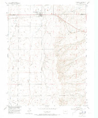
1955 Map of Strasburg
USGS Topo · Published 1973About this map
Strasburg serves as the primary hub of activity on this high plains landscape, situated precisely on the border of Adams Co and Arapahoe Co. The town’s economy and layout are closely tied to the Union Pacific railroad, which bisects the northern section of the map. Proximity to the rail line is highlighted by the presence of Elevators, essential for the agricultural transport needs of the region.
Find a feature on this map
12 named features on this map. Tap any name to fly to it.
Don’t see what you’re looking for? This feature index may not catch every label — zoom into the map to look around manually.
Map Details
Editions of this 1955 Strasburg Map
3 editions found
Other maps of this area

1949 · Bennett
USGS Topo · 1:24,000

1950 · Roper School
USGS Topo · 1:24,000

1951 · Roper School
USGS Topo · 1:24,000

1952 · Leader SW
USGS Topo · 1:24,000

1953 · Denver
USGS Topo · 1:250,000

1955 · Strasburg NW
USGS Topo · 1:24,000

1955 · Strasburg
USGS Topo · 1:24,000

1956 · Byers
USGS Topo · 1:24,000

1957 · Denver
USGS Topo · 1:250,000

1958 · Denver
USGS Topo · 1:250,000