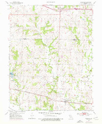
1954 Map of Strasburg
USGS Topo · Published 1976About this map
Strasburg anchors the southern portion of this landscape at a significant rail junction where the Missouri Pacific and C R I & P lines converge near the banks of Big Creek. This mid-century survey illustrates the rural transition across the Jackson Co Cass Co line, showing a network of small family and community hubs like Pleasant Grove Sch and Community Hall. The northern boundary is defined by Lone Jack, situated near a series of rest areas and the Soldiers Cem, reflecting the area's historical depth. The terrain is marked by numerous watercourses, including Crawford Creek and West Branch, which carve through the land before meeting the larger creek systems. Distinctive local landmarks such as Sloan Cem and the elevated Devil Ridge provide specific points of reference for genealogists tracing ancestral homesteads in Van Buren and Polk townships.
Find a feature on this map
22 named features on this map. Tap any name to fly to it.
Don’t see what you’re looking for? This feature index may not catch every label — zoom into the map to look around manually.
Map Details
Editions of this 1954 Strasburg Map
2 editions found
Other maps of this area

1887 · Harrisonville
USGS Topo · 1:125,000

1892 · Harrisonville
USGS Topo · 1:125,000

1894 · Harrisonville
USGS Topo · 1:125,000

1934 · Woods Chapel
USGS Topo · 1:24,000

1935 · Tarsney
USGS Topo · 1:24,000

1947 · Lawrence
USGS Topo · 1:250,000

1950 · Lawrence
USGS Topo · 1:250,000

1954 · Harrisonville
USGS Topo · 1:24,000
1954 · East Lynne
USGS Topo · 1:24,000
1954 · Kingsville
USGS Topo · 1:24,000