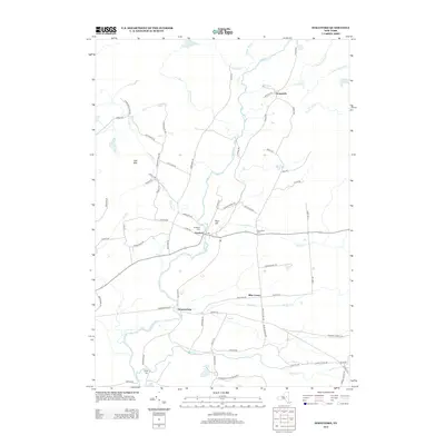
2013 Map of Stratford
USGS Topo · Published 2013About this map
E Canada Cr winds through the heart of this landscape, defining the rural character of southwestern Herkimer County. The settlement of Stratford serves as a central hub, anchored by its Po and historical burial sites like Stratford Cem. Moving south toward the Adirondack Park Preserve, the terrain transitions from the elevations of Oak Mtn and Bear Hill to the water-rich lands surrounding Sprite Cr. Smaller hamlets like Emmonsburg, Knappville, and Bliss Corner are connected by a network of local roads such as Piseco Rd and Bungytown Rd, reflecting a dispersed settlement pattern typical of the Adirondack foothills. Genealogists can trace family names through the Smith Cem and Roundtop Cem, which are scattered across this rugged territory of streams and upland woods.
Find a feature on this map
76 named features on this map. Tap any name to fly to it.
Don’t see what you’re looking for? This feature index may not catch every label — zoom into the map to look around manually.
Map Details
Editions of this 2013 Stratford Map
This is the sole edition of this map. No revisions or reprints were ever made.
Other maps of this area

1900 · Little Falls
USGS Topo · 1:62,500

1900 · Wilmurt
USGS Topo · 1:62,500

1901 · Lassellsville
USGS Topo · 1:62,500

1902 · Wilmurt
USGS Topo · 1:62,500

1903 · Lassellsville
USGS Topo · 1:62,500

1903 · Little Falls
USGS Topo · 1:62,500

1904 · Piseco Lake
USGS Topo · 1:62,500

1906 · Piseco Lake
USGS Topo · 1:62,500

1908 · Piseco Lake
USGS Topo · 1:62,500

1939 · Little Falls
USGS Topo · 1:62,500