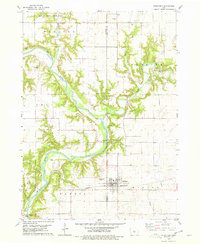
1978 Map of Stratford
USGS Topo · Published 1979About this map
The Des Moines River and Boone River carve deep, wooded valleys through the prairie landscape of Central Iowa in the late 1970s. This survey highlights the agricultural and transport corridor along the Chicago and North Western railroad, which serves the town of Stratford. The confluence of these major waterways creates a landscape of high bluffs and steep ravines, providing a natural setting for conservation and recreation at Brushy Creek State Park and Bells Mill Park.
Find a feature on this map
25 named features on this map. Tap any name to fly to it.
Don’t see what you’re looking for? This feature index may not catch every label — zoom into the map to look around manually.
Map Details
Editions of this 1978 Stratford Map
This is the sole edition of this map. No revisions or reprints were ever made.
Other maps of this area

1916 · Boone
USGS Topo · 1:62,500

1923 · Lehigh
USGS Topo · 1:62,500

1951 · Ogden
USGS Topo · 1:62,500

1954 · Waterloo
USGS Topo · 1:250,000

1954 · Fort Dodge
USGS Topo · 1:250,000

1955 · Waterloo
USGS Topo · 1:250,000

1957 · Fort Dodge
USGS Topo · 1:250,000

1958 · Fort Dodge
USGS Topo · 1:250,000

1965 · Mackey
USGS Topo · 1:24,000

1965 · Fraser
USGS Topo · 1:24,000