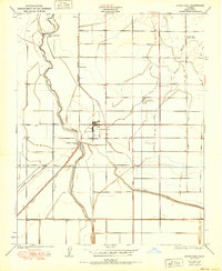
1950 Map of Stratford
USGS Topo · Published 1950About this map
Stratford serves as the central hub for this Kings County landscape, which by 1950 had become a complex network of water management and irrigation systems. The Kings River flows through the western portion of the sheet, controlled by the Upper Stratford Weir and Lower Stratford Weir. This hydrological infrastructure, featuring the Empire Canal, Jacobs Canal, and Tulare Lake Canal, reveals the intensive agricultural transformation of the Central Valley.
Find a feature on this map
21 named features on this map. Tap any name to fly to it.
Don’t see what you’re looking for? This feature index may not catch every label — zoom into the map to look around manually.
Map Details
Editions of this 1950 Stratford Map
This is the sole edition of this map. No revisions or reprints were ever made.
Other maps of this area

1926 · Hanford
USGS Topo · 1:31,680

1926 · Lethent
USGS Topo · 1:31,680

1927 · Lemoore
USGS Topo · 1:31,680

1929 · Guernsey
USGS Topo · 1:31,680

1929 · Stratford
USGS Topo · 1:31,680

1929 · Westhaven
USGS Topo · 1:31,680

1932 · El Rico Ranch
USGS Topo · 1:31,680

1933 · Kettleman City
USGS Topo · 1:31,680

1933 · Chatom Ranch
USGS Topo · 1:31,680
1935 · Chatom Ranch
USGS Topo · 1:31,680