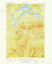
1928 Map of Stratton
USGS Topo · Published 1952About this map
Flagstaff Lake and its surrounding plantations dominate this northern Maine landscape, representing a significant transformation of the upper Dead River valley. While the topographic data reflects a 1920s survey, the map includes the 1952 addition of the reservoir, which submerged the settlement of Flagstaff. The villages of Stratton and Eustis remain as primary hubs, connected by Route 27. To the south, the massive peaks of the Redington Pond Range, Sugarloaf Mtn, and Crocker Mtn rise sharply, punctuated by remote outposts like Skunk Brook Camp. Local educational history is anchored by the Browns Sch near Eustis Ridge and the Coplin Sch in Coplin Plantation. The detailed drainage network, including the North Branch Dead River and Carrabassett River, illustrates the complex hydrology of this logging and mountain region before mid-century developments.
Find a feature on this map
70 named features on this map. Tap any name to fly to it.
Don’t see what you’re looking for? This feature index may not catch every label — zoom into the map to look around manually.
Map Details
Editions of this 1928 Stratton Map
3 editions found
Other maps of this area

1925 · Pierce Pond
USGS Topo · 1:48,000

1927 · Pierce Pond
USGS Topo · 1:62,500

1928 · Chain Lakes
USGS Topo · 1:48,000

1928 · Spencer
USGS Topo · 1:48,000

1928 · Dead River
USGS Topo · 1:62,500

1928 · Stratton
USGS Topo · 1:48,000

1929 · Phillips
USGS Topo · 1:48,000

1930 · Kingfield
USGS Topo · 1:48,000

1931 · Dead River
USGS Topo · 1:48,000

1932 · Phillips
USGS Topo · 1:62,500