
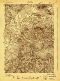
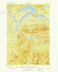
1928 Map of Stratton
USGS Topo · Published 1957About this map
Stratton and Eustis serve as the primary gateways to this mountainous corner of Franklin County, where the North Branch Dead River and South Branch Dead River meet. The landscape is dominated by the massive ridge of Bigelow Mountain and the prominent peaks of Sugarloaf Mtn and Crocker Mtn. This specific record captures a transitional period for the local geography; while the original survey was conducted in the late 1920s, it includes 1950s updates showing Flagstaff Lake and Flagstaff Pond. This indicates the dramatic change in the valley as the Dead River was impounded, a major event for genealogists tracing families from the former Flagstaff Plantation. Remote outposts like Morgan Farm and Morgan Camp provide insight into the area's historical reliance on logging and early recreation, while the Coplin Sch marks the social center for residents of Coplin Plantation.
Find a feature on this map
70 named features on this map. Tap any name to fly to it.
Don’t see what you’re looking for? This feature index may not catch every label — zoom into the map to look around manually.
Map Details
Editions of this 1928 Stratton Map
3 editions found
Historical Maps of Kingfield Through Time
254 maps found

1924 Farmington
Franklin County, ME

1926 Dixfield
Franklin County, ME

1928 Chain Lakes
Franklin County, ME

1928 Skinner
Franklin County, ME
1928 Stratton
Franklin County, ME

1929 Dixfield
Franklin County, ME

1929 Phillips
Franklin County, ME

1931 Skinner
Franklin County, ME

1932 Arnold Pond
Franklin County, ME

1932 Chain Lakes
Franklin County, ME

1932 Kennebago Lake
Franklin County, ME

1932 Phillips
Franklin County, ME

1932 Stratton
Franklin County, ME

1935 Arnold Pond
Franklin County, ME

1935 Chain Lakes
Franklin County, ME

1935 Kennebago Lake
Franklin County, ME

1936 Kennebago Lake
Franklin County, ME

1951 Chain Lakes
Franklin County, ME

1956 Dixfield
Franklin County, ME

1956 Farmington
Franklin County, ME

1956 Stratton
Franklin County, ME

1968 East Dixfield
Franklin County, ME

1968 Farmington Falls
Franklin County, ME

1968 Farmington
Franklin County, ME

1968 Mount Blue
Franklin County, ME

1968 New Sharon
Franklin County, ME

1968 Weld
Franklin County, ME

1968 Wilton
Franklin County, ME

1969 Black Mountain
Franklin County, ME

1969 Chain Of Ponds
Franklin County, ME

1969 Jim Pond
Franklin County, ME

1969 Quill Hill
Franklin County, ME

1970 Boundary Pond
Franklin County, ME

1970 Kennebago Lake
Franklin County, ME

1970 Kibby Mountain
Franklin County, ME

1970 Merrill Mountain
Franklin County, ME

1970 Skinner
Franklin County, ME

1970 Tim Mountain
Franklin County, ME

1977 Black Mountain
Franklin County, ME

1977 Black Nubble
Franklin County, ME

1977 Boundary Pond
Franklin County, ME

1977 Chain Of Ponds
Franklin County, ME

1977 Jackson Mountain
Franklin County, ME

1977 Jim Pond
Franklin County, ME

1977 Kennebago Lake
Franklin County, ME

1977 Kibby Mountain
Franklin County, ME

1977 Little Kennebago Lake
Franklin County, ME

1977 Louise Mountain
Franklin County, ME

1977 Madrid
Franklin County, ME

1977 Merrill Mountain
Franklin County, ME

1977 Mount Abraham
Franklin County, ME

1977 Northwest Pond
Franklin County, ME

1977 Phillips
Franklin County, ME

1977 Poplar Mountain
Franklin County, ME

1977 Quill Hill
Franklin County, ME

1977 Redington
Franklin County, ME

1977 Saddleback Mountain
Franklin County, ME

1977 Skinner
Franklin County, ME

1977 Stratton
Franklin County, ME

1977 Strong
Franklin County, ME

1977 Sugarloaf Mountain
Franklin County, ME

1977 Tim Mountain
Franklin County, ME

1978 Houghton
Franklin County, ME

1979 New Vineyard
Franklin County, ME

1984 Houghton
Franklin County, ME

1984 Jackson Mountain
Franklin County, ME

1984 Madrid
Franklin County, ME

1984 Mount Abraham
Franklin County, ME

1984 Phillips
Franklin County, ME

1984 Redington
Franklin County, ME

1985 Saddleback Mountain
Franklin County, ME

1986 Flagstaff Lake
Franklin County, ME

1986 Rumford
Franklin County, ME

1989 Black Nubble
Franklin County, ME

1989 New Vineyard
Franklin County, ME

1989 Poplar Mountain
Franklin County, ME

1989 Stratton
Franklin County, ME

1989 Strong
Franklin County, ME

1989 Sugarloaf Mtn
Franklin County, ME

1990 Little Kennebago Lake
Franklin County, ME

1990 Louise Mountain
Franklin County, ME

1990 Northwest Pond
Franklin County, ME

1994 Flagstaff Lake
Franklin County, ME

1994 Rumford
Franklin County, ME

1997 Houghton
Franklin County, ME

1997 Kennebago Lake
Franklin County, ME

1997 Saddleback Mountain
Franklin County, ME

1997 Stratton
Franklin County, ME

1997 Sugarloaf Mtn
Franklin County, ME

2011 Black Mountain
Franklin County, ME

2011 Black Nubble
Franklin County, ME

2011 Boundary Pond
Franklin County, ME

2011 Chain of Ponds
Franklin County, ME

2011 East Dixfield
Franklin County, ME

2011 Farmington Falls
Franklin County, ME

2011 Farmington
Franklin County, ME

2011 Houghton
Franklin County, ME

2011 Jackson Mountain
Franklin County, ME

2011 Jim Pond
Franklin County, ME

2011 Kennebago Lake
Franklin County, ME

2011 Kibby Mountain
Franklin County, ME

2011 Little Kennebago Lake
Franklin County, ME

2011 Louise Mountain
Franklin County, ME

2011 Madrid
Franklin County, ME

2011 Merrill Mountain
Franklin County, ME

2011 Mount Abraham
Franklin County, ME

2011 Mount Blue
Franklin County, ME

2011 New Sharon
Franklin County, ME

2011 New Vineyard
Franklin County, ME

2011 Northwest Pond
Franklin County, ME

2011 Phillips
Franklin County, ME

2011 Poplar Mountain
Franklin County, ME

2011 Quill Hill
Franklin County, ME

2011 Redington
Franklin County, ME

2011 Saddleback Mountain
Franklin County, ME

2011 Skinner
Franklin County, ME

2011 Stratton
Franklin County, ME

2011 Strong
Franklin County, ME

2011 Sugarloaf Mountain
Franklin County, ME

2011 Tim Mountain
Franklin County, ME

2011 Weld
Franklin County, ME

2011 Wilton
Franklin County, ME

2014 Black Mountain
Franklin County, ME

2014 Black Nubble
Franklin County, ME

2014 Boundary Pond
Franklin County, ME

2014 Chain of Ponds
Franklin County, ME

2014 East Dixfield
Franklin County, ME

2014 Farmington Falls
Franklin County, ME

2014 Farmington
Franklin County, ME

2014 Houghton
Franklin County, ME

2014 Jackson Mountain
Franklin County, ME

2014 Jim Pond
Franklin County, ME

2014 Kennebago Lake
Franklin County, ME

2014 Kibby Mountain
Franklin County, ME

2014 Little Kennebago Lake
Franklin County, ME

2014 Louise Mountain
Franklin County, ME

2014 Madrid
Franklin County, ME

2014 Merrill Mountain
Franklin County, ME

2014 Mount Abraham
Franklin County, ME

2014 Mount Blue
Franklin County, ME

2014 New Sharon
Franklin County, ME

2014 New Vineyard
Franklin County, ME

2014 Northwest Pond
Franklin County, ME

2014 Phillips
Franklin County, ME

2014 Poplar Mountain
Franklin County, ME

2014 Quill Hill
Franklin County, ME

2014 Redington
Franklin County, ME

2014 Saddleback Mountain
Franklin County, ME

2014 Skinner
Franklin County, ME

2014 Stratton
Franklin County, ME

2014 Strong
Franklin County, ME

2014 Sugarloaf Mountain
Franklin County, ME

2014 Tim Mountain
Franklin County, ME

2014 Weld
Franklin County, ME

2014 Wilton
Franklin County, ME

2018 Black Mountain
Franklin County, ME

2018 Black Nubble
Franklin County, ME

2018 Boundary Pond
Franklin County, ME

2018 Chain of Ponds
Franklin County, ME

2018 East Dixfield
Franklin County, ME

2018 Farmington Falls
Franklin County, ME

2018 Farmington
Franklin County, ME

2018 Houghton
Franklin County, ME

2018 Jackson Mountain
Franklin County, ME

2018 Jim Pond
Franklin County, ME

2018 Kennebago Lake
Franklin County, ME

2018 Kibby Mountain
Franklin County, ME

2018 Little Kennebago Lake
Franklin County, ME

2018 Louise Mountain
Franklin County, ME

2018 Madrid
Franklin County, ME

2018 Merrill Mountain
Franklin County, ME

2018 Mount Abraham
Franklin County, ME

2018 Mount Blue
Franklin County, ME

2018 New Sharon
Franklin County, ME

2018 New Vineyard
Franklin County, ME

2018 Northwest Pond
Franklin County, ME

2018 Phillips
Franklin County, ME

2018 Poplar Mountain
Franklin County, ME

2018 Quill Hill
Franklin County, ME

2018 Redington
Franklin County, ME

2018 Saddleback Mountain
Franklin County, ME

2018 Skinner
Franklin County, ME

2018 Stratton
Franklin County, ME

2018 Strong
Franklin County, ME

2018 Sugarloaf Mountain
Franklin County, ME

2018 Tim Mountain
Franklin County, ME

2018 Weld
Franklin County, ME

2018 Wilton
Franklin County, ME

2021 Black Mountain
Franklin County, ME

2021 Black Nubble
Franklin County, ME

2021 Boundary Pond
Franklin County, ME

2021 Chain of Ponds
Franklin County, ME

2021 East Dixfield
Franklin County, ME

2021 Farmington Falls
Franklin County, ME

2021 Farmington
Franklin County, ME

2021 Houghton
Franklin County, ME

2021 Jackson Mountain
Franklin County, ME

2021 Jim Pond
Franklin County, ME

2021 Kennebago Lake
Franklin County, ME

2021 Kibby Mountain
Franklin County, ME

2021 Little Kennebago Lake
Franklin County, ME

2021 Louise Mountain
Franklin County, ME

2021 Madrid
Franklin County, ME

2021 Merrill Mountain
Franklin County, ME

2021 Mount Abraham
Franklin County, ME

2021 Mount Blue
Franklin County, ME

2021 New Sharon
Franklin County, ME

2021 New Vineyard
Franklin County, ME

2021 Northwest Pond
Franklin County, ME

2021 Phillips
Franklin County, ME

2021 Poplar Mountain
Franklin County, ME

2021 Quill Hill
Franklin County, ME

2021 Redington
Franklin County, ME

2021 Saddleback Mountain
Franklin County, ME

2021 Skinner
Franklin County, ME

2021 Stratton
Franklin County, ME

2021 Strong
Franklin County, ME

2021 Sugarloaf Mountain
Franklin County, ME

2021 Tim Mountain
Franklin County, ME

2021 Weld
Franklin County, ME

2021 Wilton
Franklin County, ME

2024 Black Mountain
Franklin County, ME

2024 Black Nubble
Franklin County, ME

2024 Boundary Pond
Franklin County, ME

2024 Chain of Ponds
Franklin County, ME

2024 East Dixfield
Franklin County, ME

2024 Farmington Falls
Franklin County, ME

2024 Farmington
Franklin County, ME

2024 Houghton
Franklin County, ME

2024 Jackson Mountain
Franklin County, ME

2024 Jim Pond
Franklin County, ME

2024 Kennebago Lake
Franklin County, ME

2024 Kibby Mountain
Franklin County, ME

2024 Little Kennebago Lake
Franklin County, ME

2024 Louise Mountain
Franklin County, ME

2024 Madrid
Franklin County, ME

2024 Merrill Mountain
Franklin County, ME

2024 Mount Abraham
Franklin County, ME

2024 Mount Blue
Franklin County, ME

2024 New Sharon
Franklin County, ME

2024 New Vineyard
Franklin County, ME

2024 Northwest Pond
Franklin County, ME

2024 Phillips
Franklin County, ME

2024 Poplar Mountain
Franklin County, ME

2024 Quill Hill
Franklin County, ME

2024 Redington
Franklin County, ME

2024 Saddleback Mountain
Franklin County, ME

2024 Skinner
Franklin County, ME

2024 Stratton
Franklin County, ME

2024 Strong
Franklin County, ME

2024 Sugarloaf Mountain
Franklin County, ME

2024 Tim Mountain
Franklin County, ME

2024 Weld
Franklin County, ME

2024 Wilton
Franklin County, ME