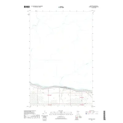
2019 Map of Stratton
USGS Topo · Published 2019About this map
The Rainy River forms a definitive international boundary in this northern frontier landscape, separating the northern United States from the Canada border. The terrain south of the river is marked by a network of drainage systems and rural transit routes, including Co Rd 124 and Co Hwy 4, which cut through the township divisions of Koochiching County. Notable watercourses such as McCloud Cr and Cameron Cr flow toward the primary river channel, while the Pinewood River meanders across the northern portion of the quadrangle. This map illustrates a sparsely settled region defined by its hydrography and the transition from riverbank to interior wetlands and township blocks, reflecting the persistent importance of the river as both a physical barrier and a geographic anchor for the surrounding land.
Find a feature on this map
18 named features on this map. Tap any name to fly to it.
Don’t see what you’re looking for? This feature index may not catch every label — zoom into the map to look around manually.
Map Details
Editions of this 2019 Stratton Map
This is the sole edition of this map. No revisions or reprints were ever made.
Other maps of this area

1919 · Birchdale
USGS Topo · 1:62,500

1954 · Roseau
USGS Topo · 1:250,000

1957 · Roseau
USGS Topo · 1:250,000

1958 · Roseau
USGS Topo · 1:250,000

1968 · Birchdale SW
USGS Topo · 1:24,000

1968 · Birchdale SE
USGS Topo · 1:24,000

1968 · Stratton
USGS Topo · 1:24,000
1968 · Birchdale
USGS Topo · 1:24,000

1968 · Border
USGS Topo · 1:24,000

1968 · Clementson SE
USGS Topo · 1:24,000