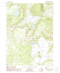
1988 Map of Strawberry Butte
USGS Topo · Published 1988About this map
Fremont National Forest defines the high-desert character of this portion of Lake County, where water management is central to the landscape. The map details a network of water resources vital for regional ranching, including Strawberry Reservoir, South Arm Reservoir, and Albertson Reservoir. These bodies of water, along with named springs like Willow Camp Spring and Adams Spring, supported the operations of remote outposts such as Reed Ranch during the late 20th century.
Find a feature on this map
42 named features on this map. Tap any name to fly to it.
Don’t see what you’re looking for? This feature index may not catch every label — zoom into the map to look around manually.
Map Details
Editions of this 1988 Strawberry Butte Map
This is the sole edition of this map. No revisions or reprints were ever made.
Other maps of this area

1886 · Alturas
USGS Topo · 1:250,000

1892 · Alturas
USGS Topo · 1:250,000

1954 · Alturas
USGS Topo · 1:250,000

1955 · Klamath Falls
USGS Topo · 1:250,000

1958 · Alturas
USGS Topo · 1:250,000

1958 · Klamath Falls
USGS Topo · 1:250,000

1960 · Strawberry Butte
USGS Topo · 1:62,500

1962 · Alturas
USGS Topo · 1:250,000

1962 · Steele Swamp
USGS Topo · 1:62,500

1962 · South Mountain
USGS Topo · 1:62,500