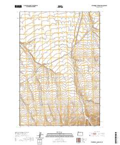
2020 Map of Strawberry Canyon SE
USGS Topo · Published 2020About this map
Sand Hollow defines the drainage pattern of this high-plateau landscape, where deep-cut ravines such as Strawberry Canyon and Little Juniper Canyon slice through the arid terrain. The map documents a rural network of roads and land divisions typical of eastern Oregon, featuring a grid of agricultural and access routes like Bombing Range Rd and Sand Hollow Rd. In the northeastern corner, the Sand Hollow Cem stands as a focal point for genealogical interest, serving the families who established homesteads across these canyon-riven lands. Further south, the landscape transitions toward Milk Canyon, where the topography becomes increasingly complex. This 2020 edition provides precise details on modern property boundaries and the persistent road names that have long anchored this high-desert community.
Find a feature on this map
28 named features on this map. Tap any name to fly to it.
Don’t see what you’re looking for? This feature index may not catch every label — zoom into the map to look around manually.
Map Details
Editions of this 2020 Strawberry Canyon SE Map
This is the sole edition of this map. No revisions or reprints were ever made.
Other maps of this area

1906 · Blalock Island
USGS Topo · 1:125,000

1908 · Blalock Island
USGS Topo · 1:125,000

1908 · Umatilla
USGS Topo · 1:125,000

1953 · Pendleton
USGS Topo · 1:250,000

1956 · Pendleton
USGS Topo · 1:250,000

1968 · Service Buttes NW
USGS Topo · 1:24,000

1968 · Swaggart Buttes
USGS Topo · 1:24,000

1968 · Lexington
USGS Topo · 1:24,000

1968 · Gleason Butte
USGS Topo · 1:24,000

1968 · Butter Creek Junction
USGS Topo · 1:24,000