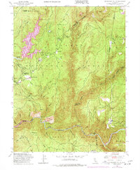
1948 Map of Strawberry Valley
USGS Topo · Published 1977About this map
Strawberry Valley and the surrounding timberlands of the Plumas National Forest and Tahoe National Forest define this 1948 landscape. The area is marked by a legacy of resource extraction, shown through sites like the Palace Mine and the Indian Hill Mine. Small settlements and camps such as Eagleville, Brandy City, and Cal-Ida are scattered across a landscape of steep ravines and ridges, including Mooreville Ridge and Peterson Ridge. The hydrology of the region is centered on the North Fork Yuba River and the Yuba River, fed by a complex network of drainages like Slate Creek and Sly Creek. Cultural landmarks such as Rose Ranch and Schwartz Meadow indicate early ranching and habitation among the hills. This survey also records the Lost Creek Reservoir, illustrating the mid-century development of water infrastructure in the Sierra Nevada foothills.
Find a feature on this map
71 named features on this map. Tap any name to fly to it.
Don’t see what you’re looking for? This feature index may not catch every label — zoom into the map to look around manually.
Map Details
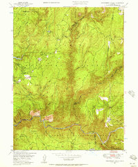
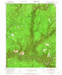
Editions of this 1948 Strawberry Valley Map
4 editions found
Historical Maps of Strawberry Valley Through Time
50 maps found

1911 Browns Valley
Yuba County, CA

1911 Ostrom
Yuba County, CA

1912 Prairie Creek
Yuba County, CA

1915 Spenceville
Yuba County, CA

1947 Browns Valley
Yuba County, CA

1948 Challenge
Yuba County, CA

1948 French Corral
Yuba County, CA

1948 Oregon House
Yuba County, CA

1948 Strawberry Valley
Yuba County, CA

1949 Browns Valley
Yuba County, CA

1949 Camp Far West
Yuba County, CA

1949 Smartville
Yuba County, CA

1950 Challenge
Yuba County, CA

1950 French Corral
Yuba County, CA

1950 Oregon House
Yuba County, CA

1950 Strawberry Valley
Yuba County, CA

1951 Camp Far West
Yuba County, CA

1951 Smartville
Yuba County, CA

1994 Strawberry Valley
Yuba County, CA

1995 Camp Far West
Yuba County, CA

1995 Challenge
Yuba County, CA

1995 French Corral
Yuba County, CA

1995 Oregon House
Yuba County, CA

1995 Smartville
Yuba County, CA

2000 Challenge
Yuba County, CA

2000 French Corral
Yuba County, CA

2012 Browns Valley
Yuba County, CA

2012 Camp Far West
Yuba County, CA

2012 Challenge
Yuba County, CA

2012 French Corral
Yuba County, CA

2012 Oregon House
Yuba County, CA

2012 Strawberry Valley
Yuba County, CA

2015 Browns Valley
Yuba County, CA

2015 Camp Far West
Yuba County, CA

2015 Challenge
Yuba County, CA

2015 French Corral
Yuba County, CA

2015 Oregon House
Yuba County, CA

2015 Strawberry Valley
Yuba County, CA

2018 Browns Valley
Yuba County, CA

2018 Camp Far West
Yuba County, CA

2018 Challenge
Yuba County, CA

2018 French Corral
Yuba County, CA

2018 Oregon House
Yuba County, CA

2018 Strawberry Valley
Yuba County, CA

2021 Browns Valley
Yuba County, CA

2021 Oregon House
Yuba County, CA

2021 Strawberry Valley
Yuba County, CA

2022 Camp Far West
Yuba County, CA

2022 Challenge
Yuba County, CA

2022 French Corral
Yuba County, CA