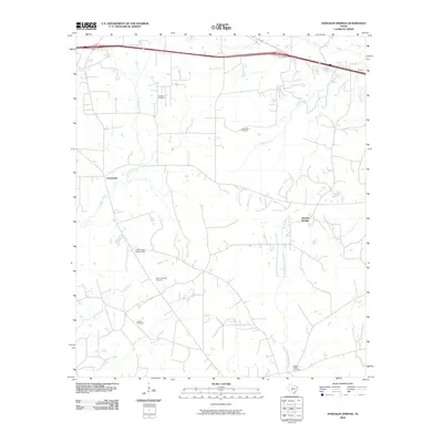
2010 Map of Stricklin Springs
USGS Topo · Published 2010About this map
Stricklin Springs and Crossroads anchor this East Texas landscape, where the headwaters of numerous creeks and bayous define the local geography. The area's history is preserved in several family and community burial grounds, including Granbury Cemetery, Long Ridge Cemetery, and Mount Prospect Cemetery. Local industry and infrastructure are represented by the Elysian Gas Field and the Elysian Fields Lookout Tower, reflecting the region's involvement in both energy production and forest management. The terrain is a complex network of waterways, with Quapaw Creek and Butler Creek flowing through the northern reaches, while the West Fork Socagee Creek and Caney Creek drain the southern sections toward Paw Paw Bayou.
Find a feature on this map
17 named features on this map. Tap any name to fly to it.
Don’t see what you’re looking for? This feature index may not catch every label — zoom into the map to look around manually.
Map Details
Editions of this 2010 Stricklin Springs Map
This is the sole edition of this map. No revisions or reprints were ever made.
Other maps of this area

1943 · Waskom
USGS Topo · 1:62,500

1944 · Caddo Lake
USGS Topo · 1:62,500

1945 · Waskom
USGS Topo · 1:62,500

1946 · Caddo Lake
USGS Topo · 1:62,500

1956 · Tyler
USGS Topo · 1:250,000

1958 · Darco
USGS Topo · 1:62,500

1962 · Stricklin Springs
USGS Topo · 1:24,000

1962 · De Berry
USGS Topo · 1:24,000
1962 · Panola
USGS Topo · 1:24,000
1962 · Waskom
USGS Topo · 1:24,000