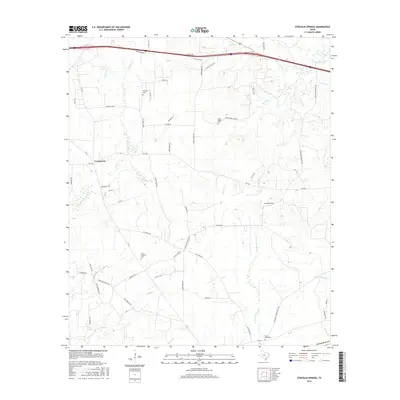
2016 Map of Stricklin Springs
USGS Topo · Published 2016About this map
Stricklin Springs and the surrounding Harrison County timberlands are defined by a network of creeks and family-named cemeteries. The landscape is primarily rural, with the community of Crossroads and the larger settlement of Stricklin Springs serving as central nodes. Several historic burial sites, including Granbury Cem, Long Ridge Cem, Mount Prospect Cem, and Elysian Fields Cem, are distributed throughout the quadrangle, suggesting long-standing family ties to the land. Drainage patterns are complex, dominated by the W Fork Socagee Cr and E Fork Socagee Cr, along with numerous smaller tributaries like Turkey Cr, Quapaw Cr, and Big Sis Cr. Transportation is anchored by Interstate 20 along the northern edge, while a web of secondary roads such as Old Town Rd and Strickland Springs Rd connect the scattered residences and farms.
Find a feature on this map
62 named features on this map. Tap any name to fly to it.
Don’t see what you’re looking for? This feature index may not catch every label — zoom into the map to look around manually.
Map Details
Editions of this 2016 Stricklin Springs Map
This is the sole edition of this map. No revisions or reprints were ever made.
Other maps of this area

1943 · Waskom
USGS Topo · 1:62,500

1944 · Caddo Lake
USGS Topo · 1:62,500

1945 · Waskom
USGS Topo · 1:62,500

1946 · Caddo Lake
USGS Topo · 1:62,500

1956 · Tyler
USGS Topo · 1:250,000

1958 · Darco
USGS Topo · 1:62,500

1962 · Stricklin Springs
USGS Topo · 1:24,000

1962 · De Berry
USGS Topo · 1:24,000
1962 · Panola
USGS Topo · 1:24,000
1962 · Waskom
USGS Topo · 1:24,000