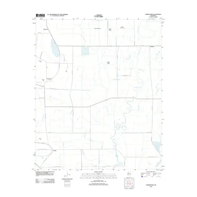
2012 Map of Stringtown
USGS Topo · Published 2012About this map
Stringtown and Priscilla anchor this rural Mississippi Delta landscape, where the flat alluvial plain is defined by an intricate network of natural bayous and engineered drainage. Settled points like Grapeland and Meltonia are connected by a grid of farm-to-market roads such as Bates Rd and Resettlement Rd, illustrating the region's agricultural focus. Family and community heritage is evident in the scattered burial grounds, including Dickerson Cem, Asia Cem, and Mount Cozy Cem. Water management is the primary topographical feature here, with names like Pistol Slough and Stillwater Bayou running alongside man-made improvements like Ditch Number C-1. The presence of Shell Lake and several branches of Bee Bayou further emphasize the low-lying, riparian character of Washington County.
Find a feature on this map
50 named features on this map. Tap any name to fly to it.
Don’t see what you’re looking for? This feature index may not catch every label — zoom into the map to look around manually.
Map Details
Editions of this 2012 Stringtown Map
This is the sole edition of this map. No revisions or reprints were ever made.
Other maps of this area

1933 · Lamont
USGS Topo · 1:62,500

1939 · Refuge
USGS Topo · 1:62,500

1939 · Lamont
USGS Topo · 1:62,500

1939 · Tralake
USGS Topo · 1:62,500

1939 · Choctaw
USGS Topo · 1:62,500

1953 · Greenwood
USGS Topo · 1:250,000

1956 · Greenwood
USGS Topo · 1:250,000

1967 · Stringtown
USGS Topo · 1:24,000
1967 · Skene
USGS Topo · 1:24,000

1967 · Leland
USGS Topo · 1:24,000