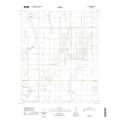
2020 Map of Stringtown
USGS Topo · Published 2020About this map
The Mississippi Delta landscape of Washington and Bolivar Counties is defined here by its complex drainage network and dispersed agricultural settlements. Small communities like Grapeland, Meltonia, and Priscilla serve as hubs for a region threaded with water bodies including Bee Bayou, Stillwater Bayou, and Snake Bayou. The map illustrates the intensive rural road system that connects these landings and hamlets, with routes like Stringtown Rd and Napanee Rd following the natural contours of the land and old property lines.
Find a feature on this map
53 named features on this map. Tap any name to fly to it.
Don’t see what you’re looking for? This feature index may not catch every label — zoom into the map to look around manually.
Map Details
Editions of this 2020 Stringtown Map
This is the sole edition of this map. No revisions or reprints were ever made.
Other maps of this area

1933 · Lamont
USGS Topo · 1:62,500

1939 · Refuge
USGS Topo · 1:62,500

1939 · Lamont
USGS Topo · 1:62,500

1939 · Tralake
USGS Topo · 1:62,500

1939 · Choctaw
USGS Topo · 1:62,500

1953 · Greenwood
USGS Topo · 1:250,000

1956 · Greenwood
USGS Topo · 1:250,000

1967 · Stringtown
USGS Topo · 1:24,000
1967 · Skene
USGS Topo · 1:24,000

1967 · Leland
USGS Topo · 1:24,000