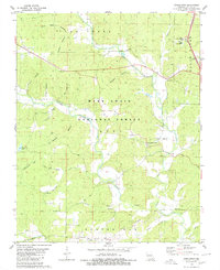
1980 Map of Stringtown
USGS Topo · Published 1980About this map
The Mark Twain National Forest dominates this section of the Ozark foothills, where narrow hollows and timbered ridges give way to the Black River valley. Small religious centers such as Bethel Chapel, Calvary Ch, and Good Hope Ch are scattered throughout the landscape, serving rural communities like Stringtown and Milltown. The topography is defined by intricate drainage systems including Tenmile Creek, Cane Creek, and Hurricane Creek, which have carved numerous named hollows like Smoky Hollow and Blue Hole Hollow. Local history is preserved in the location of the Sparkman Cem and Houts Cem, as well as institutional landmarks such as the Sears Youth Center. The transition from the high ground of Beaver Dam Ridge to the river lowlands illustrates the traditional settlement patterns of Butler County, with farms and homes clustered near reliable water sources and established forest boundaries.
Find a feature on this map
36 named features on this map. Tap any name to fly to it.
Don’t see what you’re looking for? This feature index may not catch every label — zoom into the map to look around manually.
Map Details
Editions of this 1980 Stringtown Map
This is the sole edition of this map. No revisions or reprints were ever made.
Other maps of this area

1934 · Williamsville
USGS Topo · 1:48,000

1935 · Poplar Bluff
USGS Topo · 1:62,500

1935 · Acorn
USGS Topo · 1:62,500

1935 · Harviell
USGS Topo · 1:62,500

1939 · Poplar Bluff
USGS Topo · 1:62,500

1940 · Williamsville
USGS Topo · 1:62,500

1940 · Naylor
USGS Topo · 1:62,500

1944 · Naylor
USGS Topo · 1:62,500

1949 · Poplar Bluff
USGS Topo · 1:62,500

1957 · Poplar Bluff
USGS Topo · 1:250,000