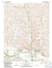
1989 Map of Strong City
USGS Topo · Published 1990About this map
Strong City and the surrounding Chase County landscape are defined by the convergence of the Cottonwood River and Fox Creek during the late 1980s. This survey illustrates the intersection of heavy rail and local industry, with the Atchison Topeka and Santa Fe railroad cutting through the valley near the Flint Hills Rodeo Grounds. Economic activity is evident in the Davis Gas Field to the northwest and several Quarries dotted near the riverbanks. For genealogists, the map preserves the locations of several community burial sites, including Simmons Cem, Strong Twp Cem, and Prairie Grove Cem. The small settlement of Neva sits at a rail junction to the west, while the local infrastructure includes a Radio Tower, Water Tank, and a specialized Feed Lot near the confluence of the major waterways.
Find a feature on this map
25 named features on this map. Tap any name to fly to it.
Don’t see what you’re looking for? This feature index may not catch every label — zoom into the map to look around manually.
Map Details
Editions of this 1989 Strong City Map
This is the sole edition of this map. No revisions or reprints were ever made.
Other maps of this area

1885 · Eskridge
USGS Topo · 1:125,000

1888 · Emporia
USGS Topo · 1:125,000

1889 · Parkerville
USGS Topo · 1:125,000

1889 · Eskridge
USGS Topo · 1:125,000

1894 · Emporia
USGS Topo · 1:125,000

1894 · Eskridge
USGS Topo · 1:125,000

1894 · Parkerville
USGS Topo · 1:125,000

1898 · Cottonwood Falls
USGS Topo · 1:125,000

1955 · Hutchinson
USGS Topo · 1:250,000
1957 · Elmdale
USGS Topo · 1:24,000