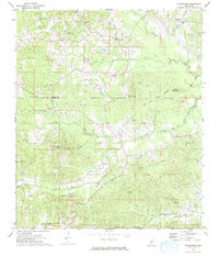
1972 Map of Stronghope
USGS Topo · Published 1974About this map
The settlement of Stronghope and the surrounding piney woods landscape are documented here during the early 1970s. This rural stretch of the Mississippi countryside is defined by an intricate network of waterways, including Bahala Creek, Wolf Pen Branch, and Fords Creek, which carve through the undulating terrain near the border of Copiah and Lincoln counties. A notable cultural landmark is the Old Indian Treaty Boundary, which runs diagonally across the landscape, marking a significant historical line of demarcation.
Find a feature on this map
31 named features on this map. Tap any name to fly to it.
Don’t see what you’re looking for? This feature index may not catch every label — zoom into the map to look around manually.
Map Details
Editions of this 1972 Stronghope Map
This is the sole edition of this map. No revisions or reprints were ever made.
Other maps of this area

1953 · Natchez
USGS Topo · 1:250,000

1956 · Natchez
USGS Topo · 1:250,000

1959 · Natchez
USGS Topo · 1:250,000

1963 · Hazlehurst
USGS Topo · 1:24,000

1963 · Shady Grove
USGS Topo · 1:24,000

1970 · Nola
USGS Topo · 1:24,000

1971 · Oma
USGS Topo · 1:24,000
1971 · Georgetown
USGS Topo · 1:24,000

1972 · Fair Oak Springs
USGS Topo · 1:24,000

1972 · Brookhaven
USGS Topo · 1:24,000