
1972 Map of Brookhaven
USGS Topo · Published 1974About this map
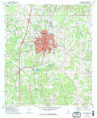
The city of Brookhaven serves as the focal point of this 1970s survey, showing a period of significant regional infrastructure alongside long-established landmarks. The Illinois Central Gulf railroad and several major roadways bisect the landscape, while the Bogue Chitto and its various forks, including the West Bogue Chitto and East Bogue Chitto, dictate the area's natural drainage. The map provides a detailed view of the town's social fabric, from the historic grounds of Whitworth College to the local Alexander High Sch. Traces of the region's earlier history are preserved in labels like the Old Ind Treaty Bdy and the Old Railroad Grade north of Smith Lake. Outlying settlements like Hartman and Carlos are depicted near active industrial sites, including numerous Oil Wells and Gravel Pits, illustrating the local extractive economy of the era.
Find a feature on this map
60 named features on this map. Tap any name to fly to it.
Don’t see what you’re looking for? This feature index may not catch every label — zoom into the map to look around manually.
Map Details
Editions of this 1972 Brookhaven Map
2 editions found
Other maps of this area

1953 · Natchez
USGS Topo · 1:250,000

1956 · Natchez
USGS Topo · 1:250,000

1959 · Natchez
USGS Topo · 1:250,000

1972 · West Lincoln
USGS Topo · 1:24,000

1972 · Fair Oak Springs
USGS Topo · 1:24,000

1972 · Midway
USGS Topo · 1:24,000

1972 · Ruth
USGS Topo · 1:24,000

1972 · Bogue Chitto
USGS Topo · 1:24,000
1972 · Stronghope
USGS Topo · 1:24,000
1972 · Zetus
USGS Topo · 1:24,000