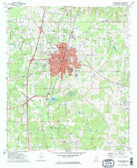
1972 Map of Brookhaven
USGS Topo · Published 1974About this map
The city of Brookhaven serves as the central hub of this 1970s survey, showing a landscape defined by the Illinois Central Gulf railroad and an extensive network of educational institutions including Whitworth College, Alexander High Sch, and Lipsey Jr High Sch. The town's layout is intricately detailed, from the residential blocks surrounding the Exchange Cem to the industrial presence of multiple Gravel Pits and various Oil Wells scattered to the south.
Find a feature on this map
56 named features on this map. Tap any name to fly to it.
Don’t see what you’re looking for? This feature index may not catch every label — zoom into the map to look around manually.
Map Details
Editions of this 1972 Brookhaven Map
2 editions found
Other maps of this area

1953 · Natchez
USGS Topo · 1:250,000

1956 · Natchez
USGS Topo · 1:250,000

1959 · Natchez
USGS Topo · 1:250,000

1972 · West Lincoln
USGS Topo · 1:24,000

1972 · Fair Oak Springs
USGS Topo · 1:24,000

1972 · Midway
USGS Topo · 1:24,000

1972 · Ruth
USGS Topo · 1:24,000

1972 · Bogue Chitto
USGS Topo · 1:24,000
1972 · Stronghope
USGS Topo · 1:24,000

1972 · Brookhaven
USGS Topo · 1:24,000