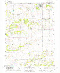
1974 Map of Stronghurst
USGS Topo · Published 1978About this map
The Santa Fe and Topeka Atchison railroad line anchors the northern corridor of this landscape, passing through the village of Stronghurst and the smaller siding at Decorra. This 1970s survey captures a rural environment defined by the headwaters of several drainages, including Honey Creek and Dugout Creek, which carve through the till plains toward the La Moine River. The map provides significant genealogical value, documenting numerous rural burying grounds such as Maple Grove Cem, Peasley Cem, and the cluster at Old Bedford Cem near the southern boundary. Local transportation and industry are represented by the Clover Landing Strip and a solitary Oil Well, reflecting a mid-century agricultural economy punctuated by small-scale private aviation and resource extraction. The community of Terre Haute stands as a primary secondary settlement in the western portion of the quadrangle.
Find a feature on this map
26 named features on this map. Tap any name to fly to it.
Don’t see what you’re looking for? This feature index may not catch every label — zoom into the map to look around manually.
Map Details
Editions of this 1974 Stronghurst Map
This is the sole edition of this map. No revisions or reprints were ever made.
Other maps of this area

1918 · La Harpe
USGS Topo · 1:62,500

1932 · Lomax
USGS Topo · 1:62,500

1934 · Oquawka
USGS Topo · 1:48,000

1934 · Burlington
USGS Topo · 1:48,000

1937 · Lomax
USGS Topo · 1:62,500

1940 · Oquawka
USGS Topo · 1:62,500

1940 · Burlington
USGS Topo · 1:62,500

1958 · Burlington
USGS Topo · 1:250,000

1961 · Burlington
USGS Topo · 1:250,000

1963 · Burlington
USGS Topo · 1:250,000