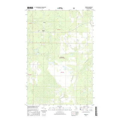
2017 Map of Strongs
USGS Topo · Published 2017About this map
Strongs and Strongs Corner stand as the primary settlements within this portion of the Hiawatha National Forest in Michigan's Upper Peninsula. The landscape is defined by a complex mosaic of wetlands and small lakes, including Betchler Lakes, Rice Lakes, and Arbutus Lake, which feed into various drainage systems like the E Br Tahquamenon River and the Pine River. Genealogists may find interest in the Coburn Cem located near the town center. The area is heavily marked by the path of the N Country National Scenic Trail, which winds south from the upper reaches of the forest. The mapping of Sullivan Creek, Black Cr, and Cr Number Eight illustrates the intricate hydrology of Chippewa County, where relatively flat terrain leads to the formation of numerous interconnected water bodies such as Stump Lake and Salt Lake.
Find a feature on this map
29 named features on this map. Tap any name to fly to it.
Don’t see what you’re looking for? This feature index may not catch every label — zoom into the map to look around manually.
Map Details
Editions of this 2017 Strongs Map
This is the sole edition of this map. No revisions or reprints were ever made.
Other maps of this area

1931 · Epoufette NE
USGS Topo · 1:31,680

1941 · Strongs
USGS Topo · 1:63,360

1951 · Strongs
USGS Topo · 1:24,000

1951 · McNearney Lake
USGS Topo · 1:24,000

1951 · Pendills Lake
USGS Topo · 1:24,000

1951 · Piatt Lake
USGS Topo · 1:24,000

1951 · Sullivan Creek
USGS Topo · 1:24,000

1951 · Eckerman
USGS Topo · 1:24,000

1951 · Strongs
USGS Topo · 1:62,500

1951 · Eckerman
USGS Topo · 1:62,500