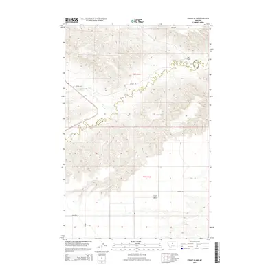
2014 Map of Strouf Island
USGS Topo · Published 2014About this map
Strouf Island and the meandering course of Arrow Cr form a natural boundary between Chouteau and Fergus counties in this central Montana landscape. The terrain is defined by deep drainage patterns and elevated flats, most notably the Arrow Creek Bench and the prominent incision of Big Coulee. This 2014 survey documents the persistence of a sparsely populated ranching and agricultural region, where connectivity relies on state route MT-80 and a network of gravel arteries like Vanderpoel Rd and Bechard Rd. The map illustrates the complex hydrology of the high plains, showing how smaller seasonal tributaries such as Cowboy Cr and Butte Cr feed into the larger creek system, which remains the primary geographic anchor for local landmarks and rural property divisions.
Find a feature on this map
17 named features on this map. Tap any name to fly to it.
Don’t see what you’re looking for? This feature index may not catch every label — zoom into the map to look around manually.
Map Details
Editions of this 2014 Strouf Island Map
This is the sole edition of this map. No revisions or reprints were ever made.
Other maps of this area

1890 · Fort Benton
USGS Topo · 1:250,000

1892 · Fort Benton
USGS Topo · 1:250,000

1897 · Fort Benton
USGS Topo · 1:250,000

1954 · Great Falls
USGS Topo · 1:250,000

1954 · Lewistown
USGS Topo · 1:250,000

1957 · Great Falls
USGS Topo · 1:250,000

1959 · Lewistown
USGS Topo · 1:250,000

1972 · Square Butte SE
USGS Topo · 1:24,000

1972 · Square Butte
USGS Topo · 1:24,000
1978 · Strouf Island
USGS Topo · 1:24,000