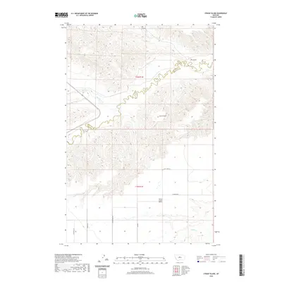
2020 Map of Strouf Island
USGS Topo · Published 2020About this map
Strouf Island and the elevated Arrow Creek Bench define this section of the Montana landscape, where the meandering course of Arrow Cr serves as the boundary between Chouteau and Fergus counties. This high-plains geography is characterized by a series of significant drainage systems, including Big Coulee to the north and the confluence of Cowboy Creek and Butte Cr. The road network, though sparse, follows the section lines and natural contours of the terrain, with local routes such as N Coffee Creek Rd and Carpenter Rd providing access to the more level benchlands above the creek breaks. The map illustrates the transition from the winding riparian corridors of Coffee Cr to the expansive, open range of the central Montana benchlands, reflecting a landscape dominated by ranching and natural topography.
Find a feature on this map
16 named features on this map. Tap any name to fly to it.
Don’t see what you’re looking for? This feature index may not catch every label — zoom into the map to look around manually.
Map Details
Editions of this 2020 Strouf Island Map
This is the sole edition of this map. No revisions or reprints were ever made.
Other maps of this area

1890 · Fort Benton
USGS Topo · 1:250,000

1892 · Fort Benton
USGS Topo · 1:250,000

1897 · Fort Benton
USGS Topo · 1:250,000

1954 · Great Falls
USGS Topo · 1:250,000

1954 · Lewistown
USGS Topo · 1:250,000

1957 · Great Falls
USGS Topo · 1:250,000

1959 · Lewistown
USGS Topo · 1:250,000

1972 · Square Butte SE
USGS Topo · 1:24,000

1972 · Square Butte
USGS Topo · 1:24,000
1978 · Strouf Island
USGS Topo · 1:24,000