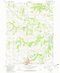
1982 Map of Stuart North
USGS Topo · Published 1983About this map
Stuart sits at the southern edge of this landscape, where the Iowa Railroad runs alongside Plunger Creek and Jim Creek. The town is characterized by its organized grid and proximity to significant local landmarks like the South Oak Grove Cem and North Oak Grove Cem. To the north, the geography is defined by the winding paths of the Middle Raccoon River and the South Raccoon River, which converge near the small settlement of Dale.
Find a feature on this map
33 named features on this map. Tap any name to fly to it.
Don’t see what you’re looking for? This feature index may not catch every label — zoom into the map to look around manually.
Map Details
Editions of this 1982 Stuart North Map
This is the sole edition of this map. No revisions or reprints were ever made.
Other maps of this area

1949 · Adel
USGS Topo · 1:62,500

1951 · Adel
USGS Topo · 1:62,500

1952 · Panora
USGS Topo · 1:62,500

1952 · Winterset
USGS Topo · 1:62,500

1954 · Greenfield
USGS Topo · 1:62,500

1954 · Omaha
USGS Topo · 1:250,000

1957 · Omaha
USGS Topo · 1:250,000

1958 · Omaha
USGS Topo · 1:250,000

1982 · Guthrie Center East
USGS Topo · 1:24,000

1982 · Panora
USGS Topo · 1:24,000