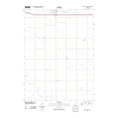
2010 Map of Stuart South
USGS Topo · Published 2010About this map
Stuart anchors the northern edge of this landscape, situated along a primary east-west transport corridor. To its south, the terrain transition into a pattern of rural land use defined by a network of waterways including Plunger Creek and the North River. Significant for local historians and genealogists, the map preserves the locations of community cornerstones like the Prairie Queen School and the North River School, as well as Calvary Cemetery and Fairview Cemetery. This rural geography is further characterized by the presence of the Wasson Landing Strip, reflecting the integration of modern small-scale aviation into the traditional agricultural backdrop. The dendritic drainage patterns of Jim Creek and the Middle River demonstrate the natural hydrology that has shaped the property lines and farm placements across the area.
Find a feature on this map
11 named features on this map. Tap any name to fly to it.
Don’t see what you’re looking for? This feature index may not catch every label — zoom into the map to look around manually.
Map Details
Editions of this 2010 Stuart South Map
This is the sole edition of this map. No revisions or reprints were ever made.
Other maps of this area

1949 · Adel
USGS Topo · 1:62,500

1951 · Adel
USGS Topo · 1:62,500

1952 · Panora
USGS Topo · 1:62,500

1952 · Winterset
USGS Topo · 1:62,500

1954 · Greenfield
USGS Topo · 1:62,500

1954 · Omaha
USGS Topo · 1:250,000

1957 · Omaha
USGS Topo · 1:250,000

1958 · Omaha
USGS Topo · 1:250,000
1982 · Redfield
USGS Topo · 1:24,000
1982 · Stuart North
USGS Topo · 1:24,000