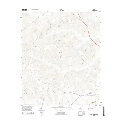
2014 Map of Stuckey Boone Lake
USGS Topo · Published 2014About this map
Cooktown lies at the junction of the Wilkinson Co and Laurens Co line, serving as a focal point in this 2014 survey of rural Georgia. The landscape is defined by the branching drainage of Cedar Cr and Maiden Cr, which flow through a network of family-held lands and rural roads. For those tracing local heritage, the map reveals several dispersed burial grounds, including Wesley Cem, Pleasant Plains Cem, and Walnut Creek Cem, often located near primary thoroughfares like Old Macon RD. Smaller water bodies such as Stuckey Boone Lake, Halls Lake, and Knights Pond are interspersed among the tributary systems of Turkey Cr and Walnut Cr. The corridor along Us-441 in the northeast provides a modern contrast to the winding historical routes like Jackson-Tyler RD and Mccue RD, reflecting the evolution of transportation in this agricultural region.
Find a feature on this map
39 named features on this map. Tap any name to fly to it.
Don’t see what you’re looking for? This feature index may not catch every label — zoom into the map to look around manually.
Map Details
Editions of this 2014 Stuckey Boone Lake Map
This is the sole edition of this map. No revisions or reprints were ever made.
Other maps of this area

1916 · Irwinton
USGS Topo · 1:62,500

1920 · Irwinton
USGS Topo · 1:62,500

1956 · Gordon
USGS Topo · 1:62,500

1956 · Jeffersonville
USGS Topo · 1:62,500

1957 · Macon
USGS Topo · 1:250,000

1958 · Macon
USGS Topo · 1:250,000

1964 · Macon
USGS Topo · 1:250,000

1973 · Massey Hill
USGS Topo · 1:24,000
1973 · Irwinton
USGS Topo · 1:24,000
1973 · Toomsboro
USGS Topo · 1:24,000