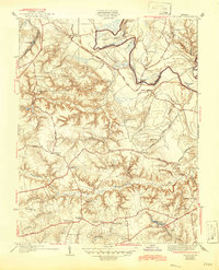
1938 Map of Studley
USGS Topo · Published 1946About this map
The Pamunkey River snakes through the northern reaches of this landscape, forming prominent landforms like Sutton Neck and Crump Neck along the border of King William Co and Hanover Co. This 1930s survey reveals a deeply dissected interior where numerous waterways, including Crump Creek and Totopotomoy Creek, have carved intricate drainage patterns into the terrain.
Find a feature on this map
44 named features on this map. Tap any name to fly to it.
Don’t see what you’re looking for? This feature index may not catch every label — zoom into the map to look around manually.
Map Details
Editions of this 1938 Studley Map
3 editions found
Other maps of this area

1894 · Richmond
USGS Topo · 1:62,500

1895 · Richmond
USGS Topo · 1:62,500

1918 · Doswell
USGS Topo · 1:62,500

1918 · Aylett
USGS Topo · 1:62,500

1920 · King William
USGS Topo · 1:62,500

1933 · Aylett
USGS Topo · 1:62,500

1934 · Seven Pines
USGS Topo · 1:24,000

1934 · Richmond
USGS Topo · 1:24,000

1938 · Seven Pines
USGS Topo · 1:31,680

1938 · Studley
USGS Topo · 1:31,680