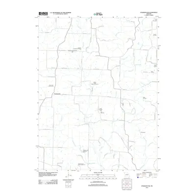
2012 Map of Sturgeon SW
USGS Topo · Published 2012About this map
Woodlandville serves as the central hub of this central Missouri landscape, where the rural character is defined by a dense network of country roads and agricultural water management systems. The hydrology of the region is notably modified by numerous containment structures such as the Callahan Creek Watershed Dam A-4 and the Boone County B-1-Dam, illustrating the 20th-century emphasis on flood control and watershed management in Boone County. For genealogists, the map preserves the locations of local burial grounds including Botner Cemetery and Dripping Spring Cemetery. The terrain is deeply etched by a system of winding waterways, including Perche Creek and the Silver Fork, which dictate the placement of early travel routes like Richland School Rd and N Locust Grove Church Rd. This survey captures the transition of a traditional farming community as it maintained its traditional landmarks while integrating modern infrastructure like the local Landing Strip.
Find a feature on this map
78 named features on this map. Tap any name to fly to it.
Don’t see what you’re looking for? This feature index may not catch every label — zoom into the map to look around manually.
Map Details
Editions of this 2012 Sturgeon SW Map
This is the sole edition of this map. No revisions or reprints were ever made.
Other maps of this area

1886 · Jefferson City
USGS Topo · 1:125,000

1888 · Boonville
USGS Topo · 1:125,000

1890 · Moberly
USGS Topo · 1:125,000

1890 · Glasgow
USGS Topo · 1:125,000

1894 · Jefferson City
USGS Topo · 1:125,000

1917 · Sturgeon
USGS Topo · 1:62,500

1935 · Columbia
USGS Topo · 1:24,000

1940 · Columbia
USGS Topo · 1:24,000

1947 · Jefferson City
USGS Topo · 1:250,000
1948 · Columbia
USGS Topo · 1:24,000