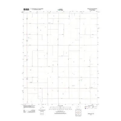
2012 Map of Sublette SE
USGS Topo · Published 2012About this map
Agricultural patterns and a strict grid of section-line roads define this portion of Seward County in the early twenty-first century. The landscape is marked by several small family and community burial grounds that provide vital links to the area's rural history and genealogical record. These include Banner Cem in the north and the Mennonite Cem in the southeastern corner, reflecting the religious and cultural heritage of the Kansas plains. Centered around a network of north-south thoroughfares like Road M and Road N, the map reveals a sparsely populated terrain where isolated homesteads are scattered among broad agricultural plots. Near the western edge, Springfield Cem serves as another historical anchor in this quiet corner of the High Plains, where the road system, from Road 15 to Road 23, maintains the orderly geometry characteristic of Western Kansas.
Find a feature on this map
18 named features on this map. Tap any name to fly to it.
Don’t see what you’re looking for? This feature index may not catch every label — zoom into the map to look around manually.
Map Details
Editions of this 2012 Sublette SE Map
This is the sole edition of this map. No revisions or reprints were ever made.
Other maps of this area

1955 · Dodge City
USGS Topo · 1:250,000

1958 · Dodge City
USGS Topo · 1:250,000

1959 · Dodge City
USGS Topo · 1:250,000

1968 · Plains SW
USGS Topo · 1:24,000

1968 · Sublette SW
USGS Topo · 1:24,000

1968 · Plains NW
USGS Topo · 1:24,000
1968 · Satanta
USGS Topo · 1:24,000

1968 · Liberal NE
USGS Topo · 1:24,000

1968 · Sublette SE
USGS Topo · 1:24,000

1968 · Liberal NW
USGS Topo · 1:24,000