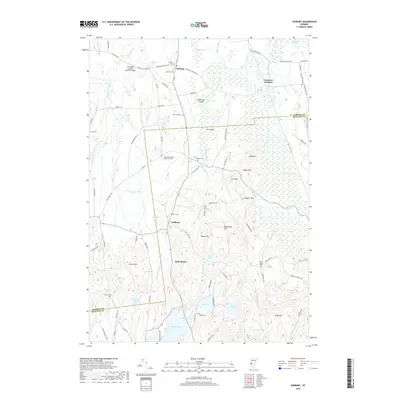
2018 Map of Sudbury
USGS Topo · Published 2018About this map
Sudbury and its surrounding countryside are defined by a complex network of wetlands and small watercourses, including the Lemon Fair River and Otter Creek. The landscape transition from the swampy lowlands of Whiting Swamp to the distinctive heights of Stiles Mtn and Signal Hill reveals the varied topography of Rutland and Addison Counties. Historic land use is evident in the numerous small family and community burial grounds, such as the G F Emmons Cem and the Crown Point Road Monument Cem, which sit alongside early transportation routes. The presence of Hyde Manor and the Shoreham Covered Railroad Bridge reflects the region's long-standing architectural and transit heritage. In the southern reach, Lake Hortonia and High Pond provide clear markers of the glacial and hydrographic patterns that shaped this Vermont corridor.
Find a feature on this map
91 named features on this map. Tap any name to fly to it.
Don’t see what you’re looking for? This feature index may not catch every label — zoom into the map to look around manually.
Map Details
Editions of this 2018 Sudbury Map
This is the sole edition of this map. No revisions or reprints were ever made.
Other maps of this area

1893 · Whitehall
USGS Topo · 1:62,500

1894 · Ticonderoga
USGS Topo · 1:62,500

1895 · Whitehall
USGS Topo · 1:62,500

1895 · Castleton
USGS Topo · 1:62,500

1896 · Ticonderoga
USGS Topo · 1:62,500

1897 · Castleton
USGS Topo · 1:62,500

1898 · Whitehall
USGS Topo · 1:62,500

1902 · Whitehall
USGS Topo · 1:62,500

1902 · Ticonderoga
USGS Topo · 1:62,500

1902 · Brandon
USGS Topo · 1:62,500