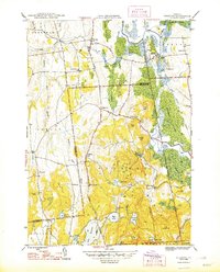
1948 Map of Sudbury
USGS Topo · Published 1948About this map
The Rutland railroad corridor and the winding course of the Lemon Fair River define the rural landscape of south-central Vermont just after the war. This survey highlights a dense network of local district education, featuring Seth Warner Sch, Webster Sch, and School No 1 scattered across the township hills. The area around Leicester Junction serves as a critical focal point where the rail lines intersect near the Otter Creek wetlands.
Find a feature on this map
54 named features on this map. Tap any name to fly to it.
Don’t see what you’re looking for? This feature index may not catch every label — zoom into the map to look around manually.
Map Details
Editions of this 1948 Sudbury Map
2 editions found
Other maps of this area

1893 · Whitehall
USGS Topo · 1:62,500

1894 · Ticonderoga
USGS Topo · 1:62,500

1895 · Whitehall
USGS Topo · 1:62,500

1895 · Castleton
USGS Topo · 1:62,500

1896 · Ticonderoga
USGS Topo · 1:62,500

1897 · Castleton
USGS Topo · 1:62,500

1898 · Whitehall
USGS Topo · 1:62,500

1902 · Whitehall
USGS Topo · 1:62,500

1902 · Ticonderoga
USGS Topo · 1:62,500

1902 · Brandon
USGS Topo · 1:62,500