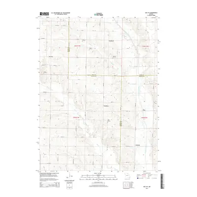
2014 Map of Sue City
USGS Topo · Published 2014About this map
Sue City and Goodland anchor this rural landscape where the borders of Macon, Knox, and Shelby Counties converge. The terrain is defined by the branching drainages of the North Fork Salt River and Bear Cr, which carve through the farmland to create a network of ridges and draws. For family historians, the area is rich with small burial grounds, including the Cupp Cemetery, Bowan Cemetery, and Blanchard Cemetery near Goodland, as well as the Mount Olive Cemetery further south near Nickellton. Local transit in this part of Missouri relies on a grid of county roads and named routes such as Orion St and Navy St, while Rays Bridge provides a crossing over the Salt River near the eastern community of Lakeland.
Find a feature on this map
58 named features on this map. Tap any name to fly to it.
Don’t see what you’re looking for? This feature index may not catch every label — zoom into the map to look around manually.
Map Details
Editions of this 2014 Sue City Map
This is the sole edition of this map. No revisions or reprints were ever made.
Other maps of this area

1903 · Edina
USGS Topo · 1:125,000

1908 · Atlanta
USGS Topo · 1:62,500

1953 · Moberly
USGS Topo · 1:250,000

1954 · Centerville
USGS Topo · 1:250,000

1954 · Moberly
USGS Topo · 1:250,000

1957 · Moberly
USGS Topo · 1:250,000

1957 · Centerville
USGS Topo · 1:250,000

1958 · Centerville
USGS Topo · 1:250,000

1960 · Moberly
USGS Topo · 1:250,000
1963 · Leonard
USGS Topo · 1:24,000