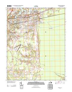
2013 Map of Suffolk
USGS Topo · Published 2013About this map
The Nansemond River and its accompanying wetlands define the northern landscape of this Virginia city, where residential development such as Westhaven Lakes and Riverview sits alongside the water's edge. This 2013 survey illustrates a dense network of neighborhoods including Philadelphia, Saratoga Place, and Collander -Bishop Meadows, reflecting the city's modern suburban character. South of the city center, the terrain opens into broader agricultural and marshy tracts, where the Suffolk Executive Airport serves as a prominent landmark.
Find a feature on this map
77 named features on this map. Tap any name to fly to it.
Don’t see what you’re looking for? This feature index may not catch every label — zoom into the map to look around manually.
Map Details
Editions of this 2013 Suffolk Map
This is the sole edition of this map. No revisions or reprints were ever made.
Other maps of this area

1907 · Norfolk
USGS Topo · 1:125,000

1919 · Smithfield
USGS Topo · 1:62,500

1919 · Suffolk
USGS Topo · 1:62,500

1921 · Newport News
USGS Topo · 1:62,500

1940 · Lake Drummond
USGS Topo · 1:62,500

1944 · Windsor
USGS Topo · 1:31,680

1945 · Lake Drummond
USGS Topo · 1:62,500

1949 · Chuckatuck
USGS Topo · 1:24,000
1952 · Bowers Hill
USGS Topo · 1:24,000

1953 · Norfolk
USGS Topo · 1:250,000