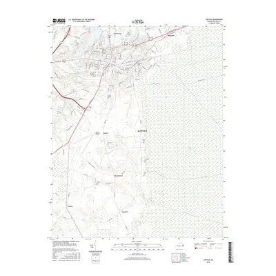
2016 Map of Suffolk
USGS Topo · Published 2016About this map
Suffolk serves as a central hub where urban development meets the vast wilderness of the Great Dismal Swamp. The map reveals a landscape defined by water management and historic burial grounds, with numerous ditches such as Washington Ditch, Middle Ditch, and Jericho Ditch cutting through the swampy eastern reaches. The residential and commercial core is densely packed with family and community history, evidenced by a high concentration of cemeteries including Cedar Hill Cem, Rosemont Cem, and Pleasant Hill Cem. To the south and west, smaller communities like Skeetertown, Russell, and Nurney are interspersed among agricultural lands and water bodies like Lake Kilby and Lake Meade. The presence of the Suffolk Executive Airport and major corridors like Portsmouth Blvd and Carolina Rd highlights the area's role as a regional transportation nexus between the coastal plains and the interior.
Find a feature on this map
116 named features on this map. Tap any name to fly to it.
Don’t see what you’re looking for? This feature index may not catch every label — zoom into the map to look around manually.
Map Details
Editions of this 2016 Suffolk Map
This is the sole edition of this map. No revisions or reprints were ever made.
Other maps of this area

1907 · Norfolk
USGS Topo · 1:125,000

1919 · Smithfield
USGS Topo · 1:62,500

1919 · Suffolk
USGS Topo · 1:62,500

1921 · Newport News
USGS Topo · 1:62,500

1940 · Lake Drummond
USGS Topo · 1:62,500

1944 · Windsor
USGS Topo · 1:31,680

1945 · Lake Drummond
USGS Topo · 1:62,500

1949 · Chuckatuck
USGS Topo · 1:24,000
1952 · Bowers Hill
USGS Topo · 1:24,000

1953 · Norfolk
USGS Topo · 1:250,000