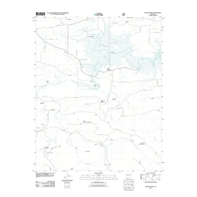
2011 Map of Sugar Grove
USGS Topo · Published 2011About this map
Sugar Grove and the surrounding Logan County countryside are defined by the winding course of the Petit Jean River, which creates a complex network of wetlands and sloughs near Horseshoe Bend. The 2011 landscape is dotted with small, family-named settlements like Logan Eddy and Mountain Grove, alongside numerous rural burial grounds such as the Ethan Davis Cemetery, Rocky Springs Cemetery, and Helton Cemetery. These sites, tucked away off routes like Old Sugar Grove RD and Jack Creek RD, provide a clear picture of the area's ancestral settlement patterns. To the south, the terrain rises toward Hole in the Ground Mountain and North Petit Jean Mountain, while the Knoppers Ford Recreation Area marks a transition into the more forested stretches along Sugar Creek.
Find a feature on this map
50 named features on this map. Tap any name to fly to it.
Don’t see what you’re looking for? This feature index may not catch every label — zoom into the map to look around manually.
Map Details
Editions of this 2011 Sugar Grove Map
This is the sole edition of this map. No revisions or reprints were ever made.
Other maps of this area

1879 · Mountain Home
USGS Topo · 1:62,500

1887 · Magazine Mountain #4
USGS Topo · 1:62,500

1887 · Mount Ida #2
USGS Topo · 1:62,500

1887 · Magazine Mountain #3
USGS Topo · 1:62,500

1887 · Magazine Mountain
USGS Topo · 1:62,500

1890 · Magazine Mountain
USGS Topo · 1:125,000

1890 · Mount Ida
USGS Topo · 1:125,000

1934 · Booneville
USGS Topo · 1:48,000

1939 · Booneville
USGS Topo · 1:62,500

1955 · Little Rock
USGS Topo · 1:250,000