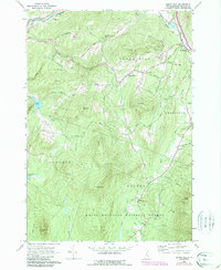
1967 Map of Sugar Hill
USGS Topo · Published 1988About this map
Sugar Hill and the town of Franconia serve as the primary hubs in this survey of Grafton County, where the landscape shifts from valley settlements to the high peaks of the White Mountain National Forest. Cultural landmarks like St Matthews Ch and Sunnyside Cem are joined by the local industry of several Gravel Pits and the Franconia Airport. The map documents a topography defined by significant water systems, including the Ammonoosuc River in the northwest and Pearl Lake to the west. Road networks like Easton Road and Lafayette Road connect these points through a terrain of named rises such as Northey Hill, Bronson Hill, and Ore Hill. This edition includes updates to woodland and development through the late 1980s, providing a clear record of the area's rural character and its mountain forest boundaries.
Find a feature on this map
58 named features on this map. Tap any name to fly to it.
Don’t see what you’re looking for? This feature index may not catch every label — zoom into the map to look around manually.
Map Details
Editions of this 1967 Sugar Hill Map
3 editions found
Other maps of this area

1900 · Whitefield
USGS Topo · 1:62,500

1929 · Moosilauke
USGS Topo · 1:62,500

1929 · Franconia
USGS Topo · 1:62,500

1931 · Littleton
USGS Topo · 1:62,500

1932 · Franconia
USGS Topo · 1:62,500

1932 · Littleton
USGS Topo · 1:48,000

1932 · Moosilauke
USGS Topo · 1:62,500

1935 · Littleton
USGS Topo · 1:62,500

1935 · Whitefield
USGS Topo · 1:48,000

1938 · Whitefield
USGS Topo · 1:62,500