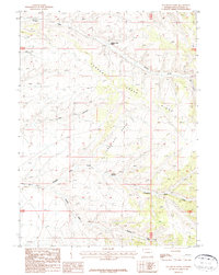
1987 Map of Sugarloaf Basin
USGS Topo · Published 1987About this map
Currant Creek Ranch and the isolated settlement of Lowe anchor this 1980s landscape in Sweetwater County. The terrain is defined by the sweeping depression of Sugarloaf Basin, bounded to the east by the rising elevation of Creek Ridge and to the south by the drainage of Washam Wash. Water management in this arid environment is evident through features like Sugarloaf Reservoir and the extensive wetlands of Sugarloaf Marsh. The map illustrates a ranching and rural economy where seasonal water sources and topographic barriers dictate the placement of homesteads and unimproved roads. Tracing the path of Currant Creek reveals the vital connection between natural drainages and the few established ranching outposts in the high desert of southwestern Wyoming.
Find a feature on this map
14 named features on this map. Tap any name to fly to it.
Don’t see what you’re looking for? This feature index may not catch every label — zoom into the map to look around manually.
Map Details
Editions of this 1987 Sugarloaf Basin Map
This is the sole edition of this map. No revisions or reprints were ever made.
Other maps of this area

1954 · Rock Springs
USGS Topo · 1:250,000

1957 · Currant Creek Ranch
USGS Topo · 1:62,500

1957 · Mc Kinnon Junction
USGS Topo · 1:62,500

1957 · Firehole Basin
USGS Topo · 1:62,500

1958 · Rock Springs
USGS Topo · 1:250,000

1962 · Rock Springs
USGS Topo · 1:250,000

1966 · Firehole Basin
USGS Topo · 1:62,500

1966 · Mc Kinnon Junction
USGS Topo · 1:62,500

1966 · Buckboard Crossing
USGS Topo · 1:62,500

1966 · Currant Creek Ranch
USGS Topo · 1:62,500