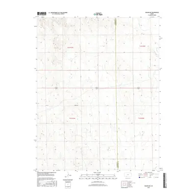
2015 Map of Sugarloaf
USGS Topo · Published 2015About this map
Sugarloaf rises as a prominent landmark in the high plains of Southwest Kansas, situated along the county line where Clark Co Comanche Co meet. This 2015 topographic survey documents a section of the Sunflower State defined by its expansive drainage patterns and remote road network. In the northern reaches, Bluff Cr meanders through the breaks of the Red Hills region, while a series of numbered section lines and rural routes, such as Sitka Rd, provide the primary access to this ranching landscape. The map reveals the meticulous Public Land Survey System grid of Townships 32 and 33 South, illustrating how the legal geography of the late 19th century continues to dictate the modern landscape of fence lines and dirt roads across the shortgrass prairie.
Find a feature on this map
27 named features on this map. Tap any name to fly to it.
Don’t see what you’re looking for? This feature index may not catch every label — zoom into the map to look around manually.
Map Details
Editions of this 2015 Sugarloaf Map
This is the sole edition of this map. No revisions or reprints were ever made.
Other maps of this area

1892 · Coldwater
USGS Topo · 1:125,000

1894 · Sitka
USGS Topo · 1:62,500

1896 · Ashland
USGS Topo · 1:125,000

1955 · Pratt
USGS Topo · 1:250,000

1959 · Pratt
USGS Topo · 1:250,000

1979 · Sitka
USGS Topo · 1:24,000

1979 · Sugarloaf
USGS Topo · 1:24,000

1979 · East Kiowa Creek South
USGS Topo · 1:24,000
1979 · Sitka SW
USGS Topo · 1:24,000
1979 · Lexington
USGS Topo · 1:24,000