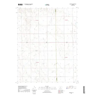
2018 Map of Sugarloaf
USGS Topo · Published 2018About this map
Sugarloaf rises as a distinct landmark in this high plains landscape along the border of Clark Co Comanche Co in southern Kansas. The terrain is defined by the dendritic drainage patterns of Bluff Cr and its tributary Buzzard Cr, which carve through the prairie and create a network of draws and breaks. The area remains primarily defined by large-scale agricultural land divisions, visible through the grid of section lines and range markers like t32s r21w and t33s r20w. While modern road designations dominate, the inclusion of Sitka Rd points to the historical connectivity of this rural corridor. This survey illustrates the persistent ranching and farming character of the region, where wide-open spaces are navigated via a precise network of routes including CR S and Ave L.
Find a feature on this map
20 named features on this map. Tap any name to fly to it.
Don’t see what you’re looking for? This feature index may not catch every label — zoom into the map to look around manually.
Map Details
Editions of this 2018 Sugarloaf Map
This is the sole edition of this map. No revisions or reprints were ever made.
Other maps of this area

1892 · Coldwater
USGS Topo · 1:125,000

1894 · Sitka
USGS Topo · 1:62,500

1896 · Ashland
USGS Topo · 1:125,000

1955 · Pratt
USGS Topo · 1:250,000

1959 · Pratt
USGS Topo · 1:250,000

1979 · Sitka
USGS Topo · 1:24,000

1979 · Sugarloaf
USGS Topo · 1:24,000

1979 · East Kiowa Creek South
USGS Topo · 1:24,000
1979 · Sitka SW
USGS Topo · 1:24,000
1979 · Lexington
USGS Topo · 1:24,000