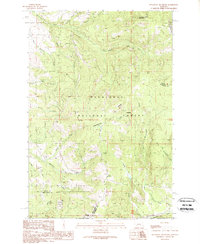
1989 Map of Sugarloaf Mountain
USGS Topo · Published 1989About this map
Sugarloaf Mountain and Cliff Mountain dominate this high-altitude landscape along the Continental Divide, where the borders of Powell, Jefferson, and Deer Lodge counties meet. The 1980s terrain is defined by a dense network of drainages including the Boulder River and Orofino Creek, which served as historical corridors for resource extraction and forestry. Evidence of earlier human activity is scattered throughout the Deerlodge National Forest, from the Schurchs Tunnel to numerous unnamed shafts and prospects indicating the area's mining history. The presence of Orofino Campground and various springs like Cold Spring suggests a transition toward recreation and conservation in the late 20th century. This map captures the intersection of industrial legacies and wilderness management, showing the rugged topography where Cottonwood Creek and Little Cottonwood Creek carve through the mountains of western Montana.
Find a feature on this map
34 named features on this map. Tap any name to fly to it.
Don’t see what you’re looking for? This feature index may not catch every label — zoom into the map to look around manually.
Map Details
Editions of this 1989 Sugarloaf Mountain Map
This is the sole edition of this map. No revisions or reprints were ever made.
Other maps of this area

1889 · Helena
USGS Topo · 1:250,000

1893 · Helena
USGS Topo · 1:250,000

1899 · Boulder
USGS Topo · 1:125,000

1899 · Helena
USGS Topo · 1:250,000

1903 · Helena
USGS Topo · 1:250,000

1947 · Butte
USGS Topo · 1:250,000

1954 · Elk Park
USGS Topo · 1:62,500

1954 · Basin
USGS Topo · 1:62,500

1958 · Butte
USGS Topo · 1:250,000

1959 · Butte North
USGS Topo · 1:62,500