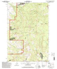
1996 Map of Sugarloaf Mountain
USGS Topo · Published 1998About this map
The Continental Divide winds through this portion of the Deerlodge National Forest, following the high ridgelines between the Powell and Jefferson county lines. This mid-1990s record of the high country highlights the extractive history of the region, featuring prospects, shafts, and mine shafts clustered near the headwaters of the South Fork Rocker Creek and Peterson Creek. The small settlement of Leadville sits at the base of the Continental Divide National Scenic Trail, serving as a waypoint in a landscape defined by prominent peaks like Sugarloaf Mountain and Black Mountain. The presence of Schurchs Tunnel and the Electronic Site on Blizzard Hill indicates the mixture of historical infrastructure and modern communications equipment maintained in this high-elevation terrain.
Find a feature on this map
36 named features on this map. Tap any name to fly to it.
Don’t see what you’re looking for? This feature index may not catch every label — zoom into the map to look around manually.
Map Details
Editions of this 1996 Sugarloaf Mountain Map
This is the sole edition of this map. No revisions or reprints were ever made.
Other maps of this area

1889 · Helena
USGS Topo · 1:250,000

1893 · Helena
USGS Topo · 1:250,000

1899 · Boulder
USGS Topo · 1:125,000

1899 · Helena
USGS Topo · 1:250,000

1903 · Helena
USGS Topo · 1:250,000

1947 · Butte
USGS Topo · 1:250,000

1954 · Elk Park
USGS Topo · 1:62,500

1954 · Basin
USGS Topo · 1:62,500

1958 · Butte
USGS Topo · 1:250,000

1959 · Butte North
USGS Topo · 1:62,500