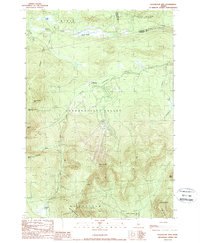
1989 Map of Sugarloaf Mtn
USGS Topo · Published 1989About this map
Carrabassett Valley defines the core of this landscape, where the South Branch Carrabassett River flows through a high-elevation corridor dominated by the mass of Sugarloaf Mtn. The late 1980s layout of the area shows a distinct transition from the wilder peaks of the Appalachian National Scenic Trail to the developing recreational infrastructure near Bigelow, including a Golf Course and utility infrastructure like a Transmission Line.
Find a feature on this map
32 named features on this map. Tap any name to fly to it.
Don’t see what you’re looking for? This feature index may not catch every label — zoom into the map to look around manually.
Map Details
Editions of this 1989 Sugarloaf Mtn Map
2 editions found
Other maps of this area

1928 · Dead River
USGS Topo · 1:62,500

1928 · Stratton
USGS Topo · 1:48,000

1929 · Phillips
USGS Topo · 1:48,000

1930 · Kingfield
USGS Topo · 1:48,000

1931 · Dead River
USGS Topo · 1:48,000

1932 · Phillips
USGS Topo · 1:62,500

1932 · Stratton
USGS Topo · 1:62,500

1932 · Kingfield
USGS Topo · 1:62,500

1944 · Dead River
USGS Topo · 1:62,500

1949 · Jackman
USGS Topo · 1:250,000
Featured Places
- Kingfield, ME
- Carrabassett Valley, ME
- Wyman Township, ME
- Dead River Township, ME
- Mount Abram Township, ME