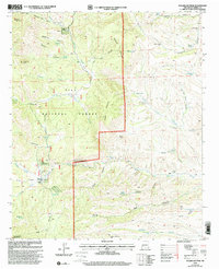
1999 Map of Sugarloaf Peak
USGS Topo · Published 2002About this map
Hermosa and its nearby extraction sites form the central activity of this high-country survey in the Gila National Forest. The landscape is dominated by the complex drainage systems of the North Fork Palomas Creek and South Fork Palomas Creek, carving deep canyons like Grapevine Canyon and Poverty Canyon through the terrain. A history of local mining is preserved in labels for the Pelican Group Mines and the Protector Mine, while the small Hermosa Cem stands as a quiet marker of the early residents who settled this corner of Sierra County. Pastoral life is noted at Dines Ranch and near various water sources like Moccasin John Well and Negro Bob Well, illustrating how early ranching depended on these critical springs and wells. The map also delineates the northern boundary of the Aldo Leopold Wilderness, where elevations rise toward prominent landmarks such as Sugarloaf Peak and Black Peak.
Find a feature on this map
67 named features on this map. Tap any name to fly to it.
Don’t see what you’re looking for? This feature index may not catch every label — zoom into the map to look around manually.
Map Details
Editions of this 1999 Sugarloaf Peak Map
This is the sole edition of this map. No revisions or reprints were ever made.
Other maps of this area

1949 · Lookout Mountain
USGS Topo · 1:62,500

1954 · Tularosa
USGS Topo · 1:250,000

1958 · Tularosa
USGS Topo · 1:250,000

1963 · Bell Mountain
USGS Topo · 1:24,000

1963 · Thumb Tank Peak
USGS Topo · 1:24,000

1963 · Reeds Peak
USGS Topo · 1:24,000

1963 · Sugarloaf Peak
USGS Topo · 1:24,000

1963 · Victoria Park
USGS Topo · 1:24,000

1963 · Apache Peak
USGS Topo · 1:24,000

1965 · Winston
USGS Topo · 1:24,000