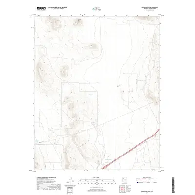
2018 Map of Sugarloaf Peak
USGS Topo · Published 2018About this map
Sugarloaf Peak dominates the northern horizon of this Yavapai County landscape, a prominent high point overlooking the high desert terrain. The topography transitions into the expansive Seventyfour Plains to the east, while Wrangler Ridge forms a distinct north-south spine across the eastern edge of the survey. This 2018 mapping reveals a network of local ranch and access roads, such as Jolly Rd and Harris Branch Rd, which navigate the drainage systems of Markham Wash. The presence of man-made water catchments like Celedonio Tank and Gabriel Tank underscores the essential infrastructure required for land management and cattle ranching in this arid environment, showing how the landscape is partitioned by section lines and traditional township boundaries including t23n r9w and t22n r8w.
Find a feature on this map
15 named features on this map. Tap any name to fly to it.
Don’t see what you’re looking for? This feature index may not catch every label — zoom into the map to look around manually.
Map Details
Editions of this 2018 Sugarloaf Peak Map
This is the sole edition of this map. No revisions or reprints were ever made.
Other maps of this area

1886 · Diamond Creek
USGS Topo · 1:250,000

1892 · Diamond Creek
USGS Topo · 1:250,000

1948 · Williams
USGS Topo · 1:250,000

1954 · Williams
USGS Topo · 1:250,000

1956 · Williams
USGS Topo · 1:250,000

1960 · Williams
USGS Topo · 1:250,000

1961 · Williams
USGS Topo · 1:250,000
1980 · Fort Rock Ranch
USGS Topo · 1:24,000
1980 · Cross Mountain
USGS Topo · 1:24,000
1980 · Squaw Peak
USGS Topo · 1:24,000