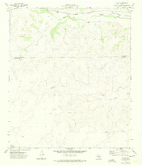
1971 Map of Suggs
USGS Topo · Published 1974About this map
The Atchison Topeka and Santa Fe railroad corridor defines the northern edge of this West Texas landscape, cutting through the drainage basin of Spring Creek and Dutch Woman Creek. The map documents a sparsely settled ranching territory straddling the Irion Co Crockett Co boundary, where the namesake settlement of Suggs sits alongside the rail line. South of the tracks, the terrain is dominated by complex drainage systems like O - Nine Draw, characterized by numerous unnamed draws and ridges that illustrate the arid geography of the Edwards Plateau. Evidence of the region's mid-century energy infrastructure appears through several Pipelines traversing the southern sections, while the presence of the De Long Ranch and scattered water infrastructure like the Water Tank reflect the enduring reliance on groundwater for livestock in this open range country.
Find a feature on this map
11 named features on this map. Tap any name to fly to it.
Don’t see what you’re looking for? This feature index may not catch every label — zoom into the map to look around manually.
Map Details
Editions of this 1971 Suggs Map
This is the sole edition of this map. No revisions or reprints were ever made.
Other maps of this area

1895 · Sherwood
USGS Topo · 1:125,000

1920 · Barnhart
USGS Topo · 1:62,500

1922 · Barnhart
USGS Topo · 1:62,500

1954 · Sonora
USGS Topo · 1:250,000

1954 · San Angelo
USGS Topo · 1:250,000

1958 · Sonora
USGS Topo · 1:250,000

1958 · San Angelo
USGS Topo · 1:250,000

1964 · Oglesby Ranch
USGS Topo · 1:24,000

1965 · San Angelo
USGS Topo · 1:250,000

1967 · Double Mill Draw NW
USGS Topo · 1:24,000